
Articles
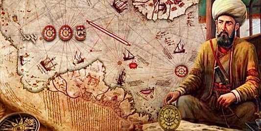
Piri Reis. La mappa misteriosa che descrive l'A...
La mappa di Piri Reis del 1513 emerge dalle profondità della storia come una delle testimonianze più straordinarie della genialità cartografica ottomana. L’ammiraglio turco Piri Reis ha saputo catturare l'immensità...
Piri Reis. La mappa misteriosa che descrive l'A...
La mappa di Piri Reis del 1513 emerge dalle profondità della storia come una delle testimonianze più straordinarie della genialità cartografica ottomana. L’ammiraglio turco Piri Reis ha saputo catturare l'immensità...
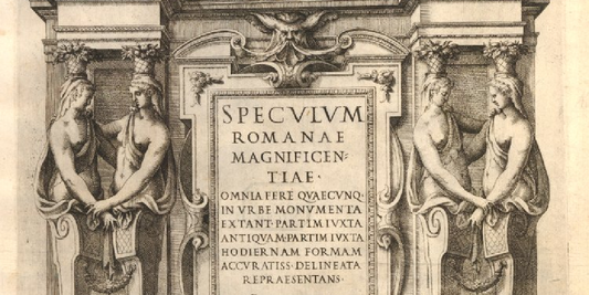
The Map of Greece in Sebastiano di Re's "Specul...
Sebastiano di Re's Map of Greece represents one of the most fascinating examples of 16th-century Renaissance cartography. The work is part of the Speculum Romanae Magnificentiae, a collection of prints...
The Map of Greece in Sebastiano di Re's "Specul...
Sebastiano di Re's Map of Greece represents one of the most fascinating examples of 16th-century Renaissance cartography. The work is part of the Speculum Romanae Magnificentiae, a collection of prints...

Important woodcut map of the Holy Roman Empire ...
This masterful work by renowned cartographer Sebastian Münster depicts the vast territory of the Holy Roman Empire with astonishing precision for the time, illustrating political boundaries, cities, rivers, and mountain...
Important woodcut map of the Holy Roman Empire ...
This masterful work by renowned cartographer Sebastian Münster depicts the vast territory of the Holy Roman Empire with astonishing precision for the time, illustrating political boundaries, cities, rivers, and mountain...
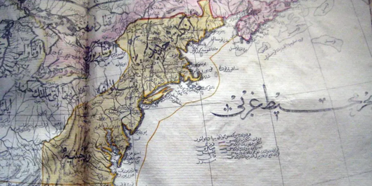
Mahmoud Raif Efendi's Rare Ottoman Map of Europ...
Mahmoud Raif Efendi's splendid map depicts Europe in the early 19th century with a political and geographical precision rare for the time, the result of a fusion of Western cartographic...
Mahmoud Raif Efendi's Rare Ottoman Map of Europ...
Mahmoud Raif Efendi's splendid map depicts Europe in the early 19th century with a political and geographical precision rare for the time, the result of a fusion of Western cartographic...
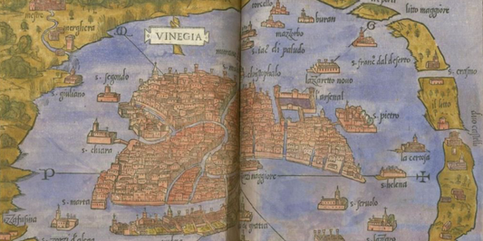
Venice and Murano in 1534 by Benedetto Bordone:...
This magnificent work by the renowned cartographer Benedetto Bordone depicts Venice and Murano surrounded by the waters of the Venetian lagoon, showcasing the urban and insular structure that made the...
Venice and Murano in 1534 by Benedetto Bordone:...
This magnificent work by the renowned cartographer Benedetto Bordone depicts Venice and Murano surrounded by the waters of the Venetian lagoon, showcasing the urban and insular structure that made the...
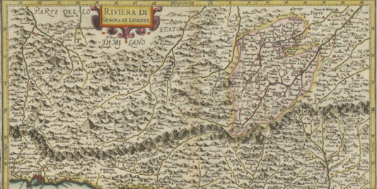
Exploring the Map of the ancient Genoese Rivier...
Antonio Mangini's Map of the Ancient Genoese Riviera del Levante depicts a striking panorama of the eastern Ligurian coast, known for its natural beauty and abundance of seaside villages. The...
Exploring the Map of the ancient Genoese Rivier...
Antonio Mangini's Map of the Ancient Genoese Riviera del Levante depicts a striking panorama of the eastern Ligurian coast, known for its natural beauty and abundance of seaside villages. The...