
Articles
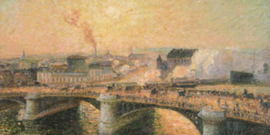
The Boieldieu Bridge at Rouen, Sunset, Misty We...
The painting depicts a glimpse of urban life in the industrial city of Rouen, where the imposing iron Boieldieu Bridge spans the Seine afternoon where the warm light of the...
The Boieldieu Bridge at Rouen, Sunset, Misty We...
The painting depicts a glimpse of urban life in the industrial city of Rouen, where the imposing iron Boieldieu Bridge spans the Seine afternoon where the warm light of the...
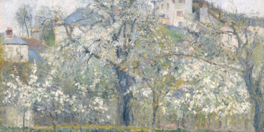
The Vegetable Garden with Trees in Blossom, Spr...
The work depicts a corner of the French countryside in full spring bloom, where plum trees show themselves in their seasonal magnificence. The scene captures a moment of natural renewal,...
The Vegetable Garden with Trees in Blossom, Spr...
The work depicts a corner of the French countryside in full spring bloom, where plum trees show themselves in their seasonal magnificence. The scene captures a moment of natural renewal,...
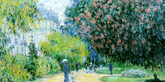
Monceau park by Claude Monet: a symphony of lig...
The work depicts a glimpse of the famous Parc Monceau in Paris, located on the Boulevard de Courcelles and surrounded by elegant houses, designed at the end of the eighteenth...
Monceau park by Claude Monet: a symphony of lig...
The work depicts a glimpse of the famous Parc Monceau in Paris, located on the Boulevard de Courcelles and surrounded by elegant houses, designed at the end of the eighteenth...
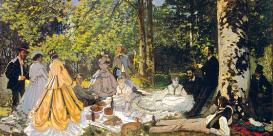
Luncheon on the Grass by Claude Monet: the cele...
The work depicts a moment of bourgeois conviviality set in the forest of Fontainebleau, near Chailly-en-Bière, where a group of elegant Parisian figures has gathered to enjoy a meal outdoors....
Luncheon on the Grass by Claude Monet: the cele...
The work depicts a moment of bourgeois conviviality set in the forest of Fontainebleau, near Chailly-en-Bière, where a group of elegant Parisian figures has gathered to enjoy a meal outdoors....
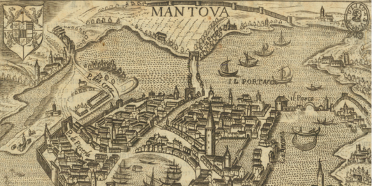
Pietro Bertelli's map of the ancient city of Ma...
The view of Mantua, created by the renowned publisher and engraver Pietro Bertelli, stands as one of the most significant cartographic records of the Lombard city at the end of...
Pietro Bertelli's map of the ancient city of Ma...
The view of Mantua, created by the renowned publisher and engraver Pietro Bertelli, stands as one of the most significant cartographic records of the Lombard city at the end of...
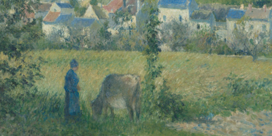
Landscape at Chaponval by Camille Pissarro: pea...
Landscape at Chaponval (Paysage à Chaponval) by Camille Pissarro depicts a rural landscape immersed in the calm and tranquility of the French countryside. A human figure is portrayed beside a...
Landscape at Chaponval by Camille Pissarro: pea...
Landscape at Chaponval (Paysage à Chaponval) by Camille Pissarro depicts a rural landscape immersed in the calm and tranquility of the French countryside. A human figure is portrayed beside a...