
Articles
The Harvest by Camille Pissarro: an intense and...
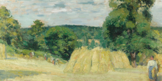
“The harvest” captures an intense and vibrant rural scene where peasants at work are engaged in harvesting wheat in a vast golden field. The figures, immersed in their activity, are...
The Harvest by Camille Pissarro: an intense and...
“The harvest” captures an intense and vibrant rural scene where peasants at work are engaged in harvesting wheat in a vast golden field. The figures, immersed in their activity, are...
Herman Moll's map of Syria and Assyria: a refin...
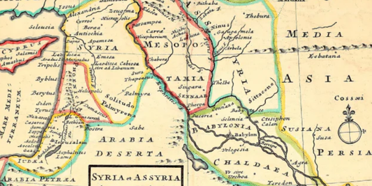
The map "Syria et Assyria ad mentem Ptolomei aliorumq" by Herman Moll represents one of the most refined 18th-century cartographic interpretations of the ancient regions of the Near East. The...
Herman Moll's map of Syria and Assyria: a refin...
The map "Syria et Assyria ad mentem Ptolomei aliorumq" by Herman Moll represents one of the most refined 18th-century cartographic interpretations of the ancient regions of the Near East. The...
Interior of the Pantheon, Rome, Giovanni Paolo ...
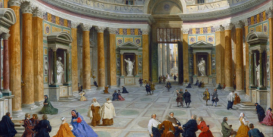
Giovanni Paolo Pannini's "Interior of the Pantheon" offers a masterful view of the interior of the famous Roman monument, capturing its majesty and sense of sacredness. The scene depicts the...
Interior of the Pantheon, Rome, Giovanni Paolo ...
Giovanni Paolo Pannini's "Interior of the Pantheon" offers a masterful view of the interior of the famous Roman monument, capturing its majesty and sense of sacredness. The scene depicts the...
Giovanni Paolo Pannini's Colosseum and the Arch...
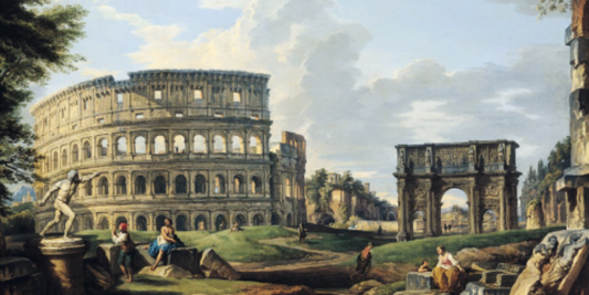
Giovanni Paolo Pannini's work masterfully depicts two of ancient Rome's most iconic monuments: the Colosseum and the Arch of Constantine. The scene opens on a monumental view of the Eternal...
Giovanni Paolo Pannini's Colosseum and the Arch...
Giovanni Paolo Pannini's work masterfully depicts two of ancient Rome's most iconic monuments: the Colosseum and the Arch of Constantine. The scene opens on a monumental view of the Eternal...
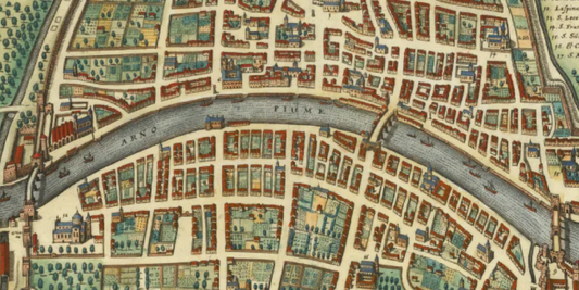
Matthäus Merian's map of Pisa: the architectura...
The map of the ancient city of Pisa created by Matthäus Merian represents an extraordinary urban view of the Tuscan city in the 17th century. The work, published in 1640...
Matthäus Merian's map of Pisa: the architectura...
The map of the ancient city of Pisa created by Matthäus Merian represents an extraordinary urban view of the Tuscan city in the 17th century. The work, published in 1640...
John Speed's map of the Ancient Roman Empire, t...
The map of the Ancient Roman Empire by John Speed represents one of the pinnacles of 17th-century English historical cartography. This majestic work, published in 1627, illustrates the territorial extent...
John Speed's map of the Ancient Roman Empire, t...
The map of the Ancient Roman Empire by John Speed represents one of the pinnacles of 17th-century English historical cartography. This majestic work, published in 1627, illustrates the territorial extent...