
Articles
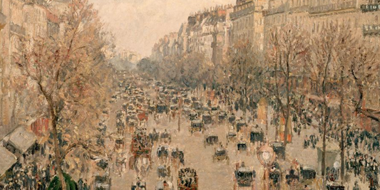
The Boulevard Montmartre, sun effect at sunset ...
The painting depicts a lively scene of Boulevard Montmartre in Paris, portrayed at the magical moment of sunset, when warm, golden light envelops the city in an atmosphere of controlled...
The Boulevard Montmartre, sun effect at sunset ...
The painting depicts a lively scene of Boulevard Montmartre in Paris, portrayed at the magical moment of sunset, when warm, golden light envelops the city in an atmosphere of controlled...
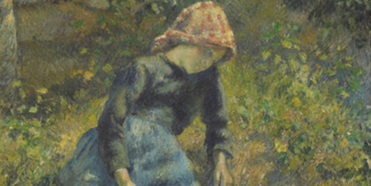
The Shepherdess by Camille Pissarro: a young pe...
This splendid work by the renowned French artist Camille Pissarro depicts a young peasant woman seated in a lush natural setting, completely immersed in the tranquility of the rural landscape....
The Shepherdess by Camille Pissarro: a young pe...
This splendid work by the renowned French artist Camille Pissarro depicts a young peasant woman seated in a lush natural setting, completely immersed in the tranquility of the rural landscape....
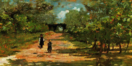
The avenue of trees with two children by Giovan...
Giovanni Fattori's "Avenue of Trees with Two Children" presents a quiet and intimate scene, in which an adult figure leads two children along a tree-lined path. The subjects, dressed simply...
The avenue of trees with two children by Giovan...
Giovanni Fattori's "Avenue of Trees with Two Children" presents a quiet and intimate scene, in which an adult figure leads two children along a tree-lined path. The subjects, dressed simply...
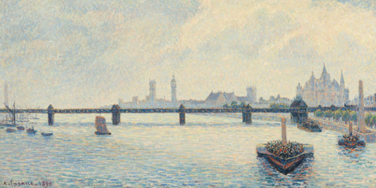
Charing Cross Bridge by Camille Pissarro: an im...
The work depicts a view of the famous Charing Cross Bridge crossing the Thames in the heart of London, capturing a moment of intense activity on the river during the...
Charing Cross Bridge by Camille Pissarro: an im...
The work depicts a view of the famous Charing Cross Bridge crossing the Thames in the heart of London, capturing a moment of intense activity on the river during the...
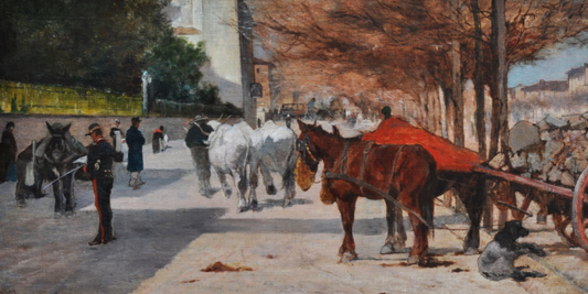
"Viale Principe Amedeo in Florence" by Giovanni...
Giovanni Fattori's "Viale Principe Amedeo in Florence" depicts an elegant city avenue bathed in the light of a calm, bright day. The scene is enlivened by a few human figures...
"Viale Principe Amedeo in Florence" by Giovanni...
Giovanni Fattori's "Viale Principe Amedeo in Florence" depicts an elegant city avenue bathed in the light of a calm, bright day. The scene is enlivened by a few human figures...
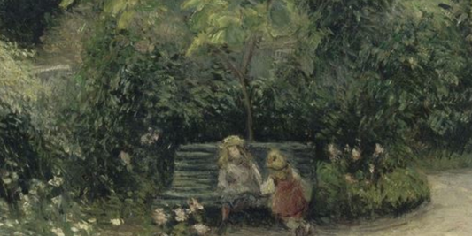
A corner of garden at the Hermitage by Camille ...
This wonderful painting by Camille Pissarro depicts a garden corner full of vegetation, where nature reveals itself in all its serenity and freshness. At the center of the scene, on...
A corner of garden at the Hermitage by Camille ...
This wonderful painting by Camille Pissarro depicts a garden corner full of vegetation, where nature reveals itself in all its serenity and freshness. At the center of the scene, on...