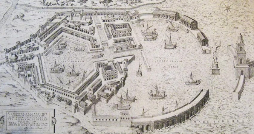
Ancient Host by Antonio Lafreri
Alice PettirossoShare
Abstract
The rare map of Ostia by Antonio Lafreri is one of the oldest cartographic representations of the Roman port city. Engraved in the 16th century , it embodies the spirit of the Renaissance , reflecting the fervent enthusiasm for antiquity. This pioneering work is not only a topographical document of great importance, but also an exceptional example of cartographic art . The Lafreri School , founded by the author, revolutionized the creation of atlases, leaving a profound mark on the cartography of the period.
Antonio Lafreri and the historical context
Antonio Lafreri (1512-1577), a French cartographer and publisher, moved to Rome around 1540, at a time when interest in Roman antiquity was experiencing a true revival. His work was part of the fervor of the excavation campaigns and the rediscovery of Roman monuments. In this scenario, Lafreri distinguished himself by producing engravings and maps that not only documented archaeological treasures, but offered a complete vision of ancient Rome and its satellite cities, such as Ostia .
The map of ancient Ostia
Lafreri 's map of Ostia is one of the first attempts to reconstruct the topography of the ancient port city . In the imperial period, Ostia was the main access point for goods destined for Rome, and his map captures its essence. The engraving shows the city's main structures: the majestic decumanus maximus, the theater, the forum, the baths, and the port. The Lafreri School , created by the author himself, became a beacon of innovation in the world of cartography , paving the way for illustrious figures such as Giacomo Gastaldi and Paolo Forlani . Their contribution made Renaissance cartography a valuable tool for historical knowledge.
Although knowledge of the time was limited compared to later excavations, Lafreri's map remains a key testimony to the early Renaissance impetus towards the study and representation of archaeological sites. The depiction of Ostia is idealized, based both on the ruins then visible and on notions of the typical structures of Roman cities.
The importance of the map
Lafreri 's map of Ostia is of inestimable historical value, as it represents one of the first efforts to document a Roman city other than Rome itself. Lafreri 's innovative approach profoundly influenced subsequent cartographic and archaeological studies, helping to shape the image of Ostia that would be refined by modern excavations. Finely engraved, this map is not only a testament to the mastery of cartographic art of the time, but also a pillar in the history of Renaissance cartography .
Even today, the map is a valuable resource for understanding the routes and main structures of the Roman city. It offers scholars a rare opportunity to compare the conditions of the ruins in the 16th century with those today, providing a unique perspective on the perception of archaeological sites during the Renaissance .
Conservation and further studies
Lafreri's engravings and maps , including the precious map of Ostia , are today preserved in museums and private collections throughout the world. Their analysis continues to be a key tool for deepening the history of Renaissance cartography . The map of Ostia remains at the center of studies by art historians and archaeologists, not only as an emblem of Renaissance interest in classical antiquity, but also as a fundamental stage in the reconstruction and understanding of the ancient city .

