
The Peutinger Table: the only surviving large-scale map of the Roman road network
Jayde BrowneThe Tabula Peutingeriana, or Peutinger Table, is a 12th-13th century copy of an ancient Roman map showing the roads of the Roman Empire, from the British Isles to the Mediterranean region and from the Middle East to the Indies and Central Asia; its western section is now lost. It bears the name of the humanist and classical scholar Konrad Peutinger, who inherited it from his friend Konrad Celtis, a librarian of Emperor Maximilian I. In 2007, it was added to the UNESCO Memory of the World Register. It is currently preserved at the National Library in Vienna.
The Tabula is likely a copy of a Carolingian-era model based on the original Roman road map. It is built as a schematic representation, and the geographical conditions, with the exception of a few details, are severely distorted. However, it provided travelers with all the relevant information on the location of the most important cities and stopping points on the Roman Empire's road network, as well as the schedule of daily stops on the main travel routes.
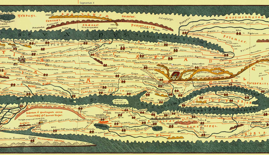
The territories are represented by horizontal bands, separated by seas. Cities are indicated by the icons of the buildings, with the convention that the larger the symbol, the more important the city. The daily stops are represented by segments of red lines. Ancient place names and distances in Roman miles are also indicated.
BUY THE REPRODUCTIONS OF THE PEUTIGER TABLE

Origin of the map: the incredible finding in a german library in 1494
The Late Antique original of this map can be traced back to several possible earlier maps, including a world map prepared by Marcus Vipsanius Agrippa (63 BC - 12 BC). It is thought that its creation was intended to illustrate the cursus publicus (i.e., the public road network along which the empire's traffic took place, equipped with post stations and services at regular intervals, which had been commissioned by Augustus).
After the emperor's death, the map was engraved on his marble tombstone and placed under the Porticus Vipsaniae, not far from the Ara Pacis, along the Via Flaminia in Rome. The original map was certainly completed after 330, as it already shows the city of Constantinople, founded during that period. Clearly, the tabula must have originally been structured through "blocks" of observation and was never updated, since the cities of Pompeii, Herculaneum, Oplontis, and Stabiae were still indicated. However, these were destroyed after the eruption of Vesuvius in 79 AD and were never rebuilt. Furthermore, several places in the province of Germania Inferior, that had been destroyed in the 5th century, are marked.
The story of the Tabula Peutingeriana continued in 1265, when a monk from Colmar transcribed an ancient Roman map from the 4th century AD. The medieval copy, made on twelve parchment sheets of which only eleven survived, represents the only evidence of what must have been an official itinerarium of the Roman Empire. In 1494, the humanist Konrad Celtis discovered it in a library in southern Germany. In 1507, Celtis donated the manuscript to Konrad Peutinger, an antiquarian from Augsburg, who gave his name to this extraordinary document. Konrad Peutinger studied law in Padua and furthered his studies in Rome; upon his return to his homeland, Emperor Maximilian appointed him imperial counselor. Peutinger wanted to publish the document, but was prevented by his death. The first edition was therefore printed in 1591 in Venice by Mark Welser of Augsburg, a relative of Konrad Peutinger, and later in Antwerp by the famous publisher Johannes Moretus.
Analysis of the map: 200,000 km of roads, cities, seas, rivers, forests and mountain ranges
The medieval map was divided into twelve segments:
Pars I: Hispania, Britannia (Segmento I)
Pars II: Lugdunum (Segmenti I, II)
Pars III: Colonia, Treveri, Argentoratae (Segmenti II, III)
Pars IV: Mediolanum (Segmenti III, IV)
Pars V: Aquilea, Regina, Lauriacum (Segmenti IV, V)
Pars VI: Roma (Segmenti V, VI)
Pars VII: Belgrado (Segmento VI)
Pars VIII: Patras (Segmenti VII, VIII)
Pars IX: Athen (Segmento VIII)
Pars X: Constantinopolis (Segmenti VIII, IX)
Pars XI: Kayseri, Trebisonda (Segmenti IX, X)
Pars XII: Antiochia (Segmenti X, XI)
Pars XIII: Urfa (Segmenti XI, XII)
Pars XIV: India (Segmento XII).
The Tablet is composed of 11 parchments assembled into a strip measuring 675 x 34 centimeters. It shows 200,000 kilometers of roads and the locations of cities, seas, rivers, forests, and mountain ranges.
The graphic technique reveals a refined miniaturist approach, where each visual element is encoded according to a precise iconographic system. The cities are represented through stylized architectural symbols that vary according to their administrative importance: towers, circular buildings, or palaces indicate minor centers, cities of medium importance, or provincial capitals, respectively. The road layouts are rendered through continuous red lines connecting the various settlements, with distances indicated in Roman miles.
The map's color scheme reflects a medieval artistic sensibility applied to an ancient content: the reds of the roads, the browns of the stylized mountains, the blues of the waterways, and the greens of the wooded areas create a visual texture that transforms consultation into an aesthetic experience. The calligraphy used for the toponyms follows the canons of 13th-century Gothic script, creating an interesting temporal dialogue between classical antiquity and medieval art. Furthermore, the distances between the stops were also indicated using local units of measurement, as in the Germanic provinces where leagues were used. One league corresponds to approximately 1,500 Roman feet, or 2.22 kilometers.
The meaning of the map in the history of art: a unique testimony of the imperial geographical image
This extraordinary map represents a unique testimony to the imperial geographical image. Its influence on subsequent cartography was profound and lasting: during the Renaissance, when scholars were rediscovering classical geography, the Tabula Peutingeriana provided invaluable information on ancient place names and the trade routes that characterized the imperial age. Even today, archaeologists and historians use this document to rebuild the territorial organization of the Roman Empire and to understand the commercial and cultural flows that characterized the ancient world. Furthermore, it captures the centrality of Rome: all roads lead, ideally, to the heart of the Empire, and it shows its absolute logistical power. It's the only surviving map showing the Roman Empire's road network on such an extended scale.
The Tabula Peutingeriana continues to be a fundamental resource for anyone studying the ancient world, representing a true work of art that testifies to the grandeur of Roman engineering and organization. Its importance unites history, geography, art, and culture in a single, extraordinary visual narrative.
For anyone wishing to bring a piece of this extraordinary and unmissable cultural heritage into their homes, it is now possible to purchase a faithful, high-quality reproduction of the Tabula Peutingeriana, in its 14 sections, on TrizioEditore.it. Produced on the finest paper, faithfully respecting the original, the map reproductions allow visitors to admire the technical mastery and geography of the ancient world in detail. These maps become tools for study and contemplation, enriching any space with their presence, rich in history and meaning.