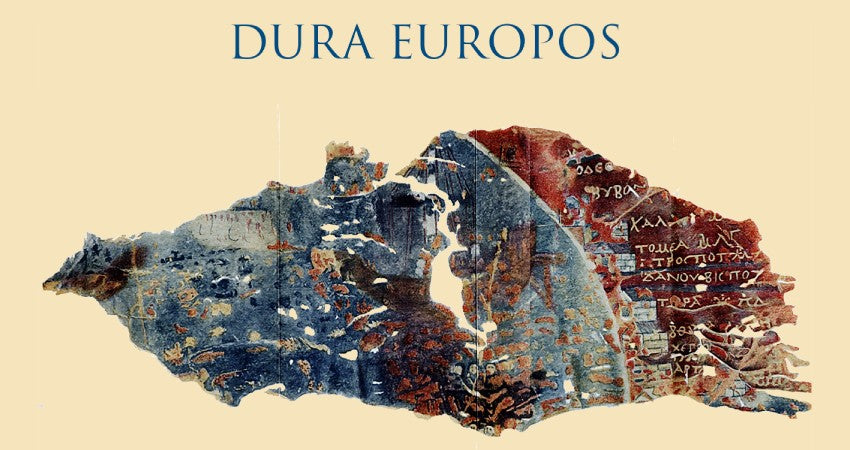
The map of Dura-Europos
Alice PettirossoShare
The Dura-Europos Map is a remarkable window into the ancient world, a tangible testimony to Roman power in the East in the 3rd century AD. Created around 230 AD , when the Cohors XX Palmyrenorum , a Roman military unit, was stationed in the region, the map paints a picture of a period of imperial supremacy. By following the paths and routes that passed through regions such as Artaxata (now Feodosia , in Crimea ), we can better understand how the Empire managed its territories shortly before events such as the Gothic invasions and the defeat at the Battle of Edessa in 260 AD began to crack its hold.
A hidden treasure of cartography : the “ shield map ” and its true nature
For a long time, the fragment was known as the " shield map ", because it was believed to be part of the leather covering of a Roman shield . However, Franz Cumont's theory has completely overturned this interpretation. The map , according to Cumont, does not have the holes necessary to fix metal elements nor the other characteristics of the shields found at the site of Dura-Europos . It would therefore be a pinax , a cartographic tablet used in the ancient world to represent coastal regions in detail.
The map is, therefore, a regional periplus , or a complete representation of the coastline of the Euxine Sea (the ancient Black Sea ) and the Sea of Azov . The periplus was a cartographic and literary genre very widespread in the Greek and Roman world, which accurately described ports, coasts and sea routes useful for navigation. In this case, the map follows the coast in a circular fashion, providing topographical and toponymic details valuable for travellers and traders of the time.
A journey through time : the discovery of the map
Discovered between 1920 and 1930 under the " archers' tower " at Dura-Europos , an ancient city on the banks of the Euphrates in modern-day Syria , the map immediately proved to be an artifact of exceptional interest. Dura-Europos , founded by the Seleucids in the 3rd century BC , had seen several dominations: from the Parthians to the Romans , up to the Sassanid conquest in 256-257 AD. Archaeologists called it the " Pompeii of the desert " for its extraordinary state of preservation, which allowed a great variety of monuments and artifacts to be brought to light, including the map .
A map that tells a world of intertwined cultures
Place names are written in Greek , while distances are indicated in Roman miles , symbolizing the fusion between the Hellenistic heritage and the power of the Roman Empire . Its circular structure, typical of the periplus , offers a detailed representation of the coasts, with useful information for both the military and for traders and navigators. Each place name and each coastal stretch depicted on the map tells us about a period in which the Eastern Mediterranean was a crossroads of cultures, languages and traditions.
Dura-Europos : a city with a cosmopolitan character
The excavations brought to light religious buildings such as a frescoed synagogue , one of the best preserved of the period, and a Christian house-church decorated with frescoes depicting biblical scenes, including " Christ walking on the water " and the " Good Shepherd ".
The city also housed a mithraeum , an underground temple dedicated to the cult of the god Mithras , characterized by an intimate atmosphere and frescoes depicting the god killing the bull, a symbol of regeneration. Among the public buildings, the palace of the Dux ripae , the residence of the military commander in charge of defending the border along the Euphrates , and the praetorium , the headquarters of the Roman garrison, stand out. Inscriptions have been found in various alphabets – Greek , Latin , Aramaic , Persian – making Dura-Europos a true meeting point between East and West .
A more detailed analysis of the map
The map measures approximately 0.45 x 0.18 metres and appears to have been created by a soldier of the Cohors XX Palmyrenorum to plan movements along the Black Sea coast. Recent studies have allowed to re-evaluate the toponymy represented: for example, " Trapezous " may not refer to the city of Trebizond , as previously thought, but to Mount Chatyr-Dag in Crimea . Also " Arta " may not be an abbreviation of Artaxata , but a Greek transliteration of the Latin term " arta " (straits), perhaps indicating the Kerch Strait . These details suggest that the map was designed not as a simple linear route, but rather as a periplus to accurately describe the conformation of the coast and the key points of navigation in the Euxine . Its exceptional preservation reminds us that, in ancient times, maps were much more than simple tools: they were works of art, symbols of power and precious treasure chests of knowledge, in which the stories and ambitions of a world in constant movement were intertwined.

