
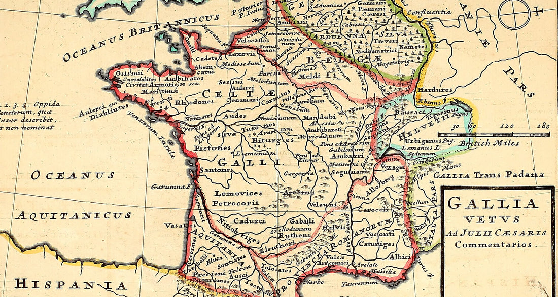
Julius Caesar's Gaul
Alice Pettirosso
Fine art print on Amalfi paper
The map of Julius Caesar's Gaul, from the Commentarii
- Printed on handmade Amalfi paper, with deckled edges
- Handmade frame in beech wood and wood pulp, or without a frame
- Sheet 29 x 42 cm (11.4 x 16.5 in), 34 x 47 cm (13.4 x 18.5 in) framed
- Trizio Editore mark blind-embossed into the paper
from €145
Pay in 3 interest-free instalments with PayPal
Tracked
and insured shipping


«Gallia est omnis divisa in partes tres»: Gaul, as a whole, is divided into three parts. With this sentence Julius Caesar opens the De bello Gallico, and with it is born the image of Gaul that Europe has studied for two thousand years: the Belgae in the north, the Aquitani in the south-west and, in between, the Celts, whom the Romans call Gauls.
On this page we retrace the conquest, from 58 to 50 BC, all the way to Alesia and Vercingetorix. At the heart of the story is the map that draws the very Gaul described by Caesar, with its peoples and its rivers: the one we chose to print by hand on Amalfi paper.
Gaul in the time of Julius Caesar: conquest and the birth of a new world
Caesar's Gaul covered much of today's France, Belgium, Luxembourg and Switzerland. It was a mosaic of Celtic peoples, each with its own political identity. Northern Italy, Cisalpine Gaul, was already Roman, and so was the Mediterranean strip, the future Gallia Narbonensis. The rest, Gallia "Comata", that is "long-haired" Gaul, was still free.
The Gallic War: Caesar and the fate of Gaul
In 58 BC Caesar launched the campaigns that would go down in history as the Gallic Wars. In eight years, through battles, alliances and repression, he brought under Rome the whole territory between the Pyrenees, the Alps, the Rhine and the Ocean. This war was the springboard for his power over the Republic.
The motives for the conquest: power and security
Caesar, proconsul of the Gauls, sought glory, wealth and political prestige. But Gaul was also a restless frontier: the migration of the Helvetii and the pressure of Ariovistus' Germans, whom Caesar faced in the very first year, threatened the borders of the Republic.
Divide et impera: Caesar's winning strategy
Caesar exploited the rivalries between the Gallic peoples, made temporary alliances and struck one tribe at a time. Only in 52 BC did the Gauls find a common leader: Vercingetorix, a nobleman of the Arverni, who united almost all of Gaul against Rome.
The siege of Avaricum: a show of strength and brutality
Avaricum, a city of the Bituriges, held out for weeks. The Romans built a huge assault ramp, which the Gauls tried to the very end to set on fire. When the city fell, Caesar himself writes that of its inhabitants, about 40,000, barely 800 survived.
Gergovia: the victory of Vercingetorix
Shortly afterwards, at Gergovia, Caesar suffered one of the rare defeats of the war. Vercingetorix defended the hilltop town and drove back the assault: almost 700 legionaries and 46 centurions fell. A victory, however, that was not enough to change the course of the war.
The masterpiece of Alesia: Roman ingenuity
In 52 BC Vercingetorix shut himself up in Alesia. Caesar surrounded it with a double line of fortifications: one facing the town, to trap the Gallic army, and one facing outwards, to fend off the relief forces. The manoeuvre succeeded, Vercingetorix surrendered and organised resistance collapsed. The Gallic leader would be executed in Rome, years later, at the end of Caesar's triumph.
The "De bello Gallico": Caesar's own account
Caesar tells the story of his war in his own voice, but speaking of himself in the third person: the Commentarii de bello Gallico, seven books written to glorify his deeds and justify them before Rome. It is a partisan account, which plays down the price paid by the Gauls, but it is also the most complete description of ancient Gaul that has come down to us.
From those pages comes the map we chose: Gallia vetus ad Julii Caesaris Commentarios, ancient Gaul drawn from Caesar's Commentaries. On the sheet you can read Gaul as Caesar divided it between Belgae, Celts and Aquitani, the peoples named in the account and the rivers the legions crossed, from the Ocean to the Rhine.
It is a map to be read at leisure. From afar, the shape of an entire country before it became France strikes you; up close, you find the names of the De bello Gallico, the ones you meet on every page of the war.
Bring Caesar's Gaul to your wall
The map of the Commentarii, printed on handmade Amalfi paper, with or without the handmade beech frame. 34 x 47 cm framed, ready to hang.
from €145 · tracked and insured shipping
Pay in 3 interest-free instalments with PayPal
Buy the mapWhy it is not a poster
A map like this can be printed on any paper. We chose the oldest paper in Italy.

Amalfi paper. Made of pure cotton fibres, thick and soft to the touch, with the deckled edges that come from making it by hand.

Handcrafted frame. In light brown beech wood, assembled by hand by our craftsmen, with hand-worked wood pulp.

Embossed mark. Every map bears the Trizio Editore mark, blind-embossed into the Amalfi paper, the sign of our workshop.
After the war: the Romanisation of Gaul
After Alesia only isolated pockets of resistance remained, crushed by 50 BC. Gaul became Roman land, but Romanisation was slow and uneven: Narbonensis, Roman for decades, quickly absorbed the language and the laws; Gallia Comata needed more time. Cities, roads and Latin gradually transformed the land of the Gauls into one of the richest regions of the empire.
That is precisely why the Gaul described by Caesar is such a precious image: it is the last portrait of that world before Rome changed it for ever. So that you can have it before your eyes, we printed the map of Julius Caesar's Gaul, drawn from his Commentarii.
Where to hang it, and who to give it to
In a study or a library, next to the Latin classics. In the office of someone who loves strategy and great undertakings. In a hallway or an entrance, where passers-by stop to look for the names of the peoples. And as a gift, for someone who has read Caesar and loves ancient history: you will not find a map like this in a bookshop.
Frequently asked questions
How big is the map?
The Amalfi paper sheet measures 29 x 42 cm (11.4 x 16.5 in); framed, the map measures 34 x 47 cm (13.4 x 18.5 in).
Can I have it with or without a frame?
Yes, you choose on the map's product page: without a frame it costs €145, with the handmade beech frame €188. With the frame it arrives ready to hang.
How is it shipped?
By express courier: shipping is tracked and insured and the map travels in reinforced packaging. When it leaves, you receive an email with the code to follow your parcel until delivery.
Can I have it in a different size or with another frame?
Yes, write to us on WhatsApp at +39 352 049 2129 or at info@trizioeditore.it and we will choose the size and frame together.
Can I pay in instalments?
Yes, with PayPal you can pay in 3 interest-free instalments, where PayPal offers this option in your country.
58–50 BC · Caesar's Gaul
The map of Julius Caesar's Gaul
Handmade Amalfi paper · Handmade beech frame · from €145
Pay in 3 interest-free instalments with PayPal
Buy the map